The Great Trigonometrical Survey

Technical Data
| Date of Issue | June 28, 2004 |
|---|---|
| Denomination | Rs. 15 |
| Quantity | 50,000 |
| Perforation | comb13½ x 13 |
| Printer | Calcutta Security Printers Ltd |
| Printing Process | Offset Lithography |
| Watermark | No Watermark |
| Colors | Multicolor |
| Credit (Designed By) | Shri Kamleshwar Singh Smt. Alka Sharma |
| Catalog Codes |
Michel IN BL26 Stamp Number IN 2067a Yvert et Tellier IN BF24 Stanley Gibbons IN MS2210 WADP Numbering System - WNS 017MS.2004 |
| Themes | Famous people | Geodesy and Surveying | Geometric Shapes | Measuring Instruments | Men |
Stamps in this Miniature Sheet

Origin of the Survey of India
The Survey of India, the premier mapping organization of the country, originated during the rule of the East India Company. The foundation of systematic surveying in India was laid under Robert Clive. In 1767, James Rennell was appointed to conduct the Bengal Surveys, marking the beginning of organized topographical mapping in India and establishing one of the oldest mapping agencies in the world.
Beginning of the Great Trigonometrical Survey
After the conquest of Mysore in 1799, detailed surveys were ordered under William Lambton. Realizing that accurate knowledge of the Earth’s size and shape was still lacking, Lambton initiated an ambitious trigonometrical survey on 10 April 1802 near Madras. This effort marked the beginning of the Great Trigonometrical Survey.
Scientific Importance of the Survey
The Great Trigonometrical Survey became one of the most remarkable scientific enterprises of the 19th century. The Royal Geographical Society regarded it as a major contribution to the advancement of geographical science. Initially planned as a short arc, the project expanded into a vast undertaking stretching nearly 1600 miles across the Indian subcontinent. The survey took almost fifty years to complete and required complex mathematical calculations long before the era of computers.
Mapping the Indian Subcontinent
Survey teams worked through extremely difficult terrain, covering regions from the southern tip of the subcontinent to the icy heights of the Himalayas. The measurements made during the survey enabled the accurate mapping of the entire Indian subcontinent. It also provided the first reliable measurements of the Himalayan peaks and helped scientists better understand the curvature and shape of the Earth.
Contribution of George Everest
The work begun by Lambton was carried forward by George Everest, who dedicated his life to completing the survey. In recognition of his contributions to geodesy and surveying, the highest peak in the world, Mount Everest, was named after him.
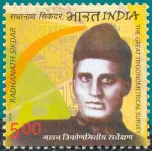
Role of Radhanath Sikdar
A key Indian contributor to the survey was Radhanath Sikdar, who joined the Survey at Mussoorie at the age of 21. He played a crucial role in calculating the height of Mount Everest and is credited with identifying it as the highest peak in the world. Sikdar also prepared the first edition of the Auxiliary Tables and assisted in compiling the Manual of Surveying for India.
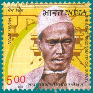
Exploration by Nain Singh Rawat
Another notable contributor was Nain Singh Rawat, who undertook daring explorations in Tibet at a time when the region was closed to outsiders. Disguised as a lama, he secretly carried scientific instruments such as a compass, sextant, thermometer, and chronometer hidden within his belongings. Over 21 months, he surveyed nearly 2000 km of trade routes, recorded numerous latitude readings, measured elevations at many locations, and followed the course of the Tsangpo River, proving that it was the same river as the Brahmaputra River.
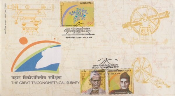
Philatelic Tribute
To honour this remarkable scientific achievement, India Post issued a Miniature Sheet of three commemorative postage stamps on the Great Trigonometrical Survey of India. The stamps feature the distinguished surveyors Radhanath Sikdar and Nain Singh Rawat, along with surveying instruments such as the theodolite, symbolizing the extraordinary efforts that led to the precise mapping of the Indian subcontinent.
First Day Cover