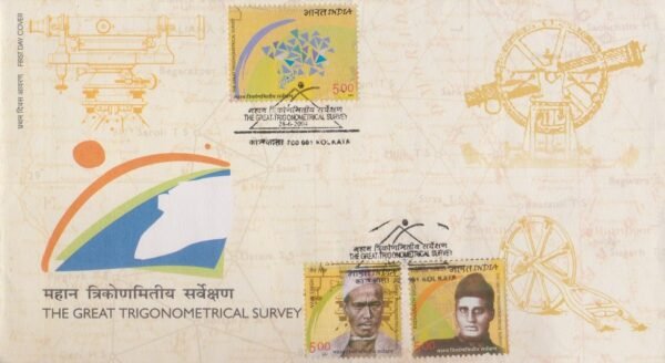
The Great Triangulation

Technical Data
| Date of Issue | June 28, 2004 |
|---|---|
| Denomination | Rs. 5 |
| Quantity | 800,000 |
| Perforation | comb 13½ x 13 |
| Printer | Calcutta Security Printers Ltd |
| Printing Process | Photogravure |
| Watermark | No Watermark |
| Colors | Multicolor |
| Credit (Designed By) | Shri Kamleshwar Singh Smt. Alka Sharma |
| Catalog Codes |
Michel IN 2030 Stamp Number IN 2067 Yvert et Tellier IN 1796 Stanley Gibbons IN 2208 WADP Numbering System - WNS IN015.04 |
| Themes | Geodesy and Surveying | Geometric Shapes |
Introduction
The Great Triangulation was one of the most remarkable scientific enterprises undertaken in the 19th century as part of the Great Trigonometrical Survey conducted by the Survey of India. Its main objective was to measure the Indian subcontinent with scientific precision and determine the exact size and shape of the Earth.
Beginning of the Survey
The project was initiated in 1802 by William Lambton, who began the survey near Madras. At that time, knowledge about the Earth’s exact dimensions and curvature was limited. Lambton therefore undertook the ambitious task of measuring a long chain of triangles across the Indian peninsula using precise instruments and mathematical calculations.
Scale and Scientific Achievement
What started as a small survey gradually expanded into an enormous scientific project covering nearly 1600 miles across the Indian subcontinent. The work took almost fifty years to complete and involved solving extremely complex mathematical equations in the pre-computer age. Survey teams worked through challenging landscapes, ranging from the southern tip of India to the frozen heights of the Himalayas.
The Royal Geographical Society regarded the Great Trigonometrical Survey and its triangulation work as one of the greatest scientific contributions of the 19th century.
Continuation under George Everest
After Lambton’s death, the work of triangulation was continued and expanded by George Everest. Under his leadership, the project achieved greater precision and extended its measurements across vast regions of the subcontinent. The highest peak of the Himalayas, Mount Everest, was later named in his honour.
Indian Contributors
The success of the Great Triangulation also depended on the efforts of many talented Indian surveyors and mathematicians. Among them was Radhanath Sikdar, who played a key role in mathematical calculations and is credited with determining the height of Mount Everest. Another important contributor was Nain Singh Rawat, who conducted daring explorations and surveys in Tibet, mapping important routes and geographical features.
Significance
The Great Triangulation made it possible to produce accurate maps of the entire Indian subcontinent. These maps supported scientific research, administration, infrastructure development, and geographical exploration. The survey also contributed significantly to understanding the curvature of the Earth and the accurate measurement of the Himalayan mountain range.
Commemorative Postage Stamp
To celebrate this monumental scientific achievement, India Post issued a commemorative postage stamp on the Great Trigonometrical Survey of India. The stamps highlight the contributions of Radhanath Sikdar and Nain Singh Rawat, along with surveying instruments such as the theodolite, symbolizing the remarkable effort behind the precise measurement and mapping of the Indian subcontinent.
First Day Cover